
A Study of Temasek, Longyamen, Guanyu, and Lingga Island in the <Zheng He Nautical Charts>
(Singapore) Captain Lim Keow Wah
I. Place Names in the Singapore Strait in the Zheng He Nautical Charts
During the Chenghua era (1465–1487), Emperor Xianzong of the Ming Dynasty ordered the Ministry of War to investigate the archives of Zheng He’s seven voyages to the Western Oceans, which began in the third year of the Yongle reign (1405). However, the old records had already vanished—possibly hidden and later destroyed by Liu Daxia, a director of the Ministry of War. The *Mao Kun Map*茅坤图 in Mao Yuanyi’s 茅元仪Treatise on Military Preparedness (Wubei Zhi武备志, 1621) is the only surviving nautical chart from the *Zheng He Nautical Charts*郑和航海图. It consists of 20 pages (40 maps) of navigational routes and 109 sailing courses. The routes depicted align with the main fleet’s path during Zheng He’s seventh voyage, suggesting the chart was likely produced after the fourth month of the eighth year of the Xuande reign (1433). The chart measures 20.3 cm in height and 560 cm in total length, documenting place names, coastal structures, islands, mountains, reefs, shoals, straits, and waterways from the departure at Longjiang Pass龙江关 (Page 3) to Hormuz (Page 23). It also includes four pages of "stellar navigation charts" for crossing the Indian Ocean.
Interpreting the *Zheng He Nautical Charts* is challenging for modern readers, particularly regarding the Singapore Strait’s place names, such as Temasek, Longyamen龙牙门 (Dragon’s Teeth Gate), and others. There are several reasons for this:
1. The original chart was a long, right-to-left handscroll map without precise measurements or proportional scaling, unlike modern Mercator projections.
2. Although Singapore has 63 islands, only five are labeled on the chart: Temasek, Changyao Isle长腰屿 (long island), Pipa Isle琵琶屿, Guanyu官屿, and White Reef白礁.
3. Over 600 years, many place names have changed, and Chinese transcriptions of local pronunciations were often inaccurate. Later rulers also renamed locations or used different languages and meanings. Some places had multiple names, while different locations shared similar names, or correct names were misapplied to nearby area or island.
Scholars have long debated the historical and modern identities of these place names. Xu Yunqiao许云樵 argued that Temasek淡马锡 and Longyamen 龙牙门both referred to Singapore. Han Huaizhun韩槐准 believed Temasek (or Danmaxi单马锡) was near Kota Tinggi in Johor, while Longyamen or Lingyamen凌牙门 was located near the Johor River estuary. Lin Woling contended that the Changyao Isle 长腰岛passed by Zheng He’s fleet was not in the Singapore Strait and that the Longyamen龙牙门 mentioned was in the Riau Islands, not Singapore.
With extensive maritime experience in these waters and a long-standing interest in Zheng He’s voyages and the *Zheng He Nautical Charts*, this paper examines the fleet’s route 600 years ago by analyzing ancient texts, sailing courses, depths, and modern maritime science.
Page 16 of the *Zheng He Nautical Charts* (from *Wubei Zhi*, Vol. 240) depicts the route from Malacca’s Guang Chang(Official Base官厂) through the Singapore Strait to White Reef in the east (Figure 1). Page 15 shows the route from White Reef past Kelantan to Con Dao (off southern Vietnam), while another section details the passage from Malacca through the Karimun Strait to Jambi, Palembang, and Java (Figure 2). For clarity, this study annotates the ancient names with modern equivalents based on Yuan, Ming, Qing, and 16th–17th century Western and local sources.
1. The Mercator projection maintains relatively stable length distortion across different parts of the terrain, enabling accurate depiction of landforms, navigation routes, and distances.
2. Han Huaizhun, "Singapore is Not the Ancient Temasek: A Study," *Nanyang Digest*, vol. 2, no. 4, 1960, pp. 51–58.
3. Lin Wuling, *A New Study on Longyamen*, Singapore: South Seas Society, 1999.
4. Due to limited or insufficient historical records, the identification of one or two small islands may be inaccurate, but these are not significant locations.

Figure 1: The route from Malacca to White Reef (Pedra Branca) in eastern Singapore.

Figure 2: Routes from White Reef ( Pedra Branca ) to Kelantan, Con Dao, and Indonesia.
In Figure 1, the Singapore Strait’s main channel is marked with a slightly curved dotted line running west to east, accompanied by a brief note:
"From Karimun Isle, five gengs (1 geng=2.4 hours); steer Yi-Chen乙辰 (course 112.5deg.) and Dan-Chen丹辰 courses (120 deg.) to Changyao Isle长腰屿, then exit Longyamen. From Longyamen, steer Jiamao甲卯 course (82.5 deg.) for five gengs to reach White Reef to exit the strait". This 34-character description outlines the sequence: passing south of Changyao Isle, Temasek Gate, Pipa Isle琵琶屿, Longyamen, and Guanyu官屿 before exiting the strait north of White Reef.
In Figure 2, the route from Indonesia’s Bintan Island to Jambi includes an island labeled "Longyamen" near White Reef and Pulau Aur, depicted with twin peaks resembling a "brush holder mountain." The chart typically uses "isle"屿 (yu) for low-lying islands and "mountain"山 (shan) for taller landforms, suggesting this "Longyamen"龙牙门 (Dragon’s Teeth Gate) was a high peak.
Several questions arise:
1. Which modern island corresponds to Changyao Isle长腰屿 (long island)?
2. Why does the chart mention "exiting Longyamen" in the Singapore Strait without specifying its location?
3. Why is "Longyamen" in the chart not in Singapore waters but instead on the highest peak of Lingga Island in Indonesia’s Riau Archipelago?
(1) Temasek and Longyamen
Temasek: During the Yuan Dynasty, Singapore was called Temasek or Singapura. Archaeological evidence places the Temasek kingdom’s royal citadel on Fort Canning Hill (formerly "Royal Hill") beside the Singapore River (Figure 3).
Wang Dayuan’s汪大渊Dao Yi Zhi Lue《岛夷志略》 (1349) records:
"Longyamen: Two mountains of Temasek intersect like dragon’s teeth, forming a channel. The land is barren, with little rice, and the climate is hot."
The same text mentions Bancur班卒 (Malay for "spring"), likely referring to the royal bathing site’s spring on Fort Canning’s western slope, Pancur Larangan. Until the 19th century, ships anchored offshore sourced fresh water from this spring, transported via the Singapore River (Figure 3).
Ma Huan马欢, an interpreter on three of Zheng He’s voyages, wrote in *Yingya Shenglan瀛涯胜览. Malacca*:
"From Champa (modern Vietnam), sail due south with fair winds for eight days to reach Longyamen. Enter the passage and head west for two days to reach Malacca."

Figure 3 The Temasek citadel on Fort Canning Hill and Bancur 班卒spring.
*Longyamen龙牙门 (Dragon’s Teeth Gate) *: This name refers to two rock pillars resembling dragon’s teeth at the western entrance to Keppel Harbour, each about 10 meters tall. Historical maps suggest these sedimentary rocks, with iron oxide veins and coarse sand grains (5mm diameter), once stood near present-day Labrador Park. The southern rock (width twice its height) was traditionally thought to be off Tanjong Rimau, Sentosa, but writer’s new research places it 70 meters offshore at 254° from Tanjong Berlayar Beacon, marked as Berlayar Rock depth 6 fathoms (depth 11 meters). The eastern pillar (*Lott’s Wife Rock*, height twice its width) was 10 meters southeast of Tanjong Berlayar’s cliff. The Malays anciently referred to it as the Sailing Stone (Batu Berlayar). Figure 5 shows a 1709 hand-drawn nautical chart of the sea pillars at Longyamen by an anonymous artist, depicting the Sailing Stone or Lott’s Wife rock to the north, as well as dwellings along the northern shore of Keppel Harbour within Longyamen. Figure 6 is a landscape painting from 1823, in which the British referred to the slender, pointed rock on the right (viewed facing west from Keppel Harbour) as Lott’s Wife stone.
The central channel between the sea pillars of Long Ya Men was only 100 meters wide, with a depth of 40 meters (22 fathoms). Upon passing between the two pillars at the entrance to Keppel Harbour, ships would encounter shores lined with tall trees. Historical records note that as vessels sailed through, their masts would brush against the overhanging branches, and pirates would leap down from the trees to raid the ships. In 1848, the British government blasted away these two sea pillars of Long Ya Men (Figure 7) to widen the Keppel waterway.
(Note: "Lott’s Wife" is likely a reference to the biblical story of Lot's wife, who turned into a pillar of salt. The name was used by British sailors/navigators to describe the rock formation due to its pillar-like appearance.)

Figure 4: 1604 hydrographic map of Singapore by Emanuel Godinho de Eredia.

Figure 5: 1709 hand-drawn chart of Longyamen 龙牙门.

Figure 6: 1823 sketch of Lott’s Wife Rock )

Figure 7: Original locations of the two rocks, now submerged off Labrador Park.
Eredia, a Portuguese officer, noted that a *shahbandar* (harbor master) Figure 4 appointed by the Johor Sultanate was stationed at the Singapore River as early as 1398. His 1604 map also marked Tanjong Rhu, Bedok River, Tanah Merah, and Changi Point.
The Singapore Strait was the shortest route from the South China Sea to the Malacca Strait and Indian Ocean. Thus, beyond being a navigational chokepoint, Singapore served as an anchorage for trade, water, and supplies—far more than the "small fishing village" described by Raffles in 1819. It was a key node in Zheng He’s maritime Silk Road and the spice trade, though records from the Ming court and Temasek Kingdom are scarce.
(2) Ming Dynasty Navigation Technology and Instruments
The Qianxing Ban牵星板 (Star-Measuring Board) was an instrument used to measure the altitude of celestial bodies (primarily the North Star) above the horizon. It consisted of 12 square boards (with different angles) and was used in conjunction with the "Ocean Star-Charting Diagram" to determine latitude when crossing the Indian Ocean.
The Zhenlu 针路 (Sailing directions/Compass Route) was based on 24 directional bearings, differing from the modern 360° compass. Each bearing was spaced 15° apart, and when shared between two adjacent bearings, it was further subdivided into 48 bearings, each spaced 7.5° apart (Figure 8). Navigation directions were determined using a compass. While the liquid compass from the Song Dynasty was still in use, some were replaced by dry compasses during the Ming Dynasty. Zheng He’s fleet used liquid compasses (Figure 9). Fragments of a Yuan Dynasty blue-and-white porcelain liquid compass bowl with the character "筭" (homophonic and synonymous with "算," meaning "calculation") were excavated from Fort Canning Hill.
The Geng更 served as a unit of time and distance for measuring each leg of a voyage. 1 day = 10 Gengs, 1 Geng = 2.4 hours. In ancient times, 1 Geng (2.4 hours) typically referred to a sailing speed of 60 li里 (30 km / 1.853 nautical miles) = 16.18 nautical miles / 2.4hrs = 6.7 knots (nautical miles per hour). However, given Zheng He’s fleet of around 200 large ships, maintaining formation amid varying winds, currents, and frequent course adjustments in narrow straits likely reduced the speed by half.
Dashui" 打水(Sounding) was the term for measuring water depth. The unit of measurement was the Tuo 托 (the span of outstretched arms, approximately 1.5 meters). A lead weight attached to a marked rope was used to determine depth (Figure 10). The concave base of the lead weight was filled with materials like lard to collect samples of seabed sediment, coral, or sand. If nothing adhered, the bottom was likely hard rock. Hydrographic records helped approximate the ship’s location.

Figure 8: Compass with 24-Bearings

Figure 9: Yuan dynasty blue-and-white porcelain liquid Compass bowl excavated from Fort Canning Hill

Figure 10: Sounding lead weight recovered from the Song dynasty shipwreck “Nanhai I南海I号”
II. Comparison of Historical and Modern Place Names in “Zheng He’s Nautical Charts”
The following are comparisons of place names in “Zheng He’s Nautical Charts” with their modern equivalents:
Malacca (满剌加): Present-day Melaka (Malacca) along the Melaka River. The Sultan’s palace was located on the southeastern bank near the river mouth.
“Guang Chang官厂” (Official Base): Described in 《The Overall Survey of the Western Ocean西洋番国志, 1434》as a temporary trade hub and base for Zheng He’s fleet. It featured wooden palisades, four gates with watchtowers, an inner fortified wall, and warehouses. Located on the northwest bank of the Melaka River, its estimated dimensions were 500×600 meters bounded by the river, coastline, and a protective fort (Figure 11). Excavations revealed a well, Ming Dynasty coins, a bronze censer inscribed "Made in the Xuande Reign of the Great Ming大明宣德年制"(Figure 11A) and Ming Yongle 永乐porcelain shards, and ship rudder blade of width 4m and height 3m. “ Guang Chang官厂” (Official Base) is for repair of ship (evidenced by the remaining of Jalan Tukang Besi (blacksmith street), warehouse for stowage of bronze money, provision and cargoes use. Dispatch smaller groups of ship to different ports. Regroup at anchorage between estuary of Malacca river and Pulau Malacca to fully load with provisions and cargoes, and set sail together for the return voyage to China. A similar “Guang Chang官厂” (Official Base) established on an island at Lhokseumawe near coast of Sumatra, Indonesia was abandoned after Zhenghe set up the Official Base (官厂) in Malacca .(Note, please refer to author’s article on “Official Base In Sumatra苏门答腊官厂”).

Figure 11: Approximate Boundaries of Zheng He’s Guang Chang官厂” (Official Base) in Melaka

Figure 11A: Xuande Reign Bronze Censer Discovered in the Zheng He’s "General’s Well" in Melaka
Shooting Arrow Mountain (射箭山) Present-day *Gunung Banang (432.38 m) near Batu Pahat, Malaysia.
Bisong Island (毘宋屿): Pulau Pisang an island off Malaysia’s west coast, lighthouse now operate by Singapore.
The Brothers Islands (平洲): In the southern Malacca Strait, now part of Indonesia with a light house on it.
Karimun Islands (吉利门): Divided into Great Karimun and Little Karimun in Indonesia.
Sugar Shallows (沙糖浅): Now Pulau Nipa (Tree Island), Indonesia, a critical but hazardous navigation marker.
Cooling Umbrella Islet (凉伞屿): Present-day Pulau Pelampung (Red Island), Indonesia, 3 nautical miles southeast of Pulau Nipa.
Long Waist Islet (长腰屿): Likely Pulau Satumu (Coney Island), Singapore, home to the Raffles Lighthouse. During Ming, it may have referred to Singapore Island itself. 17th-18th century Portuguese called it the Long Island. 3 nautical miles south west of it is the Pulau Pelampung, this this narrowest stretch is only 3 nautical miles wide, east west bound ships must change the course at this most dangerous passage to avoid grounding.
Buffalo Rock (牛屎礁): A hazardous reef in the Singapore Strait, known as Karang Banteng (bull coral in Indonesian) in Indonesian waters. A very important and dangerous point in the strait.
Loquat Islet (琵琶屿): Possibly Pulau Sebarok, Singapore, though further confirmation is needed.
Anak Sambu (琶挠屿): A small island in the southern Singapore Strait (Indonesia).
Temasek (淡马锡): The 14th-century name for Singapore’s ancient kingdom also call Singapura, Long Island. “Zheng He’s Nautical Charts” erroneously placed it on the Malay Peninsula’s southern tip rather than the island.
Temasek Gate (淡马锡门): Refers to the strait south of Long Waist Islet (长腰屿) in the Singapore Main Strait, a narrow passage (~3 nautical miles wide) requiring precise navigation adjustments.
Official Island (官屿, Singapore) : Present-day St. John’s Island (Pulau Sakijang Bendera), Singapore (Figure 12). Two other Official Islands appear in the “Zheng He’s Nautical Charts” on Pulau Berhala (near Lingga islands Indonesia) and the Maldives, likely serving as smaller transit hubs. It must have the following conditions: at a traffic hub, deep waters, sheltered anchorage, with fresh water supply, a trading and transhipment hub for food and cargoes.

Figure 12: Guanyu 官屿(Official Island Singapore) – 1965 Nautical Chart (Depths in Fathoms, Heights in Feet)
Dragon’s Teeth Gate龙牙门 (Long yamen Strait): Originally referring to two rock pillars at Keppel Harbour’s entrance, the term later also denoted and referred to the passage stretch south of the Official Island官屿 (St. John’s Island Singapore) in the Singapore Main Strait—a safer direct route for Zheng He’s massive fleet.
Ujong Tanah (答那溪屿): Old name for Johor, Malaysia, meaning "Land’s End."
Batam Island (鳌鱼山): Mislocated in the charts should not be south of Pedra Branca; should be 18.3 nautical miles southwest of Pedra Branca.
Saddle Mountain (马鞍山): Current Bintan Island Home to *Gunung Bintan Besar (360 m); its charted position was incorrect. Should not be on the west, but should be 8 nautical miles south of Pedra Branca.
White Reef (白礁): Pedra Branca a critical white granite outcrop (37×60 m at low tide) marking the eastern entrance to the Singapore Strait, now hosting the Singapore Horsburgh Lighthouse.
Luohan Mountain (罗汉屿): Present-day Pulau Lima a five-islet group forming the northern counterpart to Pedra Branca at the strait’s narrowest point (~16.5–60 m depth) in line with the old Chinese record depth of 15 Tuos托(22.5m).
Kunlun Mountain(昆仑山): Present-day Con Dao Islands, Vietnam.
Terengganu (丁加下路): On Malaysia’s northeast coast.
Pahang Port (彭杭港): At the mouth of the Kuantan River, Malaysia.
Tioman Island (苎麻山): Off Malaysia’s southeast coast.
Pulau Aur (东竹山) : An island east of Tioman.
General Island (将军屿): Pulau Tinggi off Malaysia’s southeast coast.
Lingga Island (凌牙岛): The largest island in the Lingga Archipelago (Pulau Lingga, Figure 13), located 95 nautical miles directly south of Bintan Island, Indonesia. The island measures 88 km in length and 30 km at its widest point. In its southwest stands Daik Mountain, 1,165 meters high, featuring two small pointed stone pillars at its summit resembling teeth (Figure 14; originally three pillars, now only two remain). The name "Lingga" relates to the Hindu phallic symbol "lingam," representing male genitalia, and visually corresponds to the two mountain pillars. During the Yuan, Ming, and Qing dynasties, this area was referred to as Lingga Island, Longyamen Mountain, Longya Mountain, Longya Grand Mountain, and the Lingga Kingdom – names inspired by the dragon tooth-like appearance of the two stone pillars on the 1,165-meter peak. Elderly Teochew locals still call it "Dragon Tooth Mountain" in the Teochew dialect. Notably, while the *Zheng He Navigation Map* specifically labels this island as "Longyamen" 龙牙门(Dragon Tooth Gate), this term does not appear in other historical texts. This creates confusion with Singapore’s "Longyamen" 龙牙门– a distinct sea rock formation. To differentiate: names containing characters like 凌 (Ling), 岛 (island), 大 (grand), 山 (mountain), or 雅 (ya) typically refer to Indonesia’s Lingga Island. When "Longyamen" appears alone, historical context – such as departure/destination points, nearby landmarks, or shipping routes – must be analysed to determine whether it denotes Singapore’s maritime rock formation or Indonesia’s Lingga Island.
Yuan dynasty traveller Wang Dayuan described Singapore’s Longyamen as "where the two peaks of Temasek intersect like dragon teeth, with a navigable channel between them" – highlighting the critical distinction: Singapore’s sea-level stone pillars allowed ship passage through their central waterway, unlike the non-navigable mountain pillars of Indonesia’s Lingga Island.

Figure 13: Lingga Island凌牙岛, Indonesia

Figure 14: The "Dragon Teeth" Pinnacles of Daik Mountain, Lingga Island, Lingga Mountain龙雅山, Lingga Great Mountain龙雅大山
Singkep Island (三佛屿): The second-largest island in the Lingga group, 5 nautical miles southwest of Lingga Island.
Bangka Island (彭加山): A large island (400×50 km) between Sumatra and Borneo. Distance to Sumatra is 11 nautical miles.
Pulau Berhala (Official Island官屿, Indonesia) : A small island (1×0.5 km) in the strait between Sumatra and Singkep, possibly a minor Zheng He transit point or external base.
Pulau Rangsang (Ghost Island鬼屿) : A long island (50×15 km) north of Sumatra, separated from Great Karimun by the *Gelam Strait (13 nautical miles wide) *.
Pulau Sugi Atas/Bawa (东吉山) : Near Indonesia’s *Durian Strait*, northeast of Pulau Durian South west of Batam (Fig. 27).
Kampar Port (甘巴港) : Homonymic character of the old kingdom of Sumatra. At the mouth of Sumatra’s Kampar River (Figure 27).
Kampar Gate (甘巴门) : Now the Gelam Strait, a narrow passage flanked by Belembang Reef (牛毗礁) and Batu Buruk (仁义礁) (Figure 27).
Belembang Reef (牛毗礁):Two small reefs Pulau Belembang(length 50m)和Pulau Burung(length 120m)separated by 1 nautical mile, 4.5 nautical miles south east of Pulau Rangsang, 6 nautical miles outside the estuary of Kampar river (Fig. 27).
Benevolence Reef仁义礁:Batu Buruk a 200m length reef in the Sumatra Gelam Strait, located south East 1.3 nautical miles of Belembang Reef (Fig. 27).
Notes:
*Dragon’s Teeth Gate* distinctions:
*Singapore*: Refers to *sea pillars** forming a navigable channel.
*Indonesia (Lingga Island) *: Refers to *mountain pinnacles* (non-navigable).
*Official Base/Island (官厂/官屿) *: Functioned as logistics hubs, requiring strategic locations with deep anchorages, freshwater, and trade access
III. Investigation of Zheng He’s Maritime Routes in the Waters Around Singapore
From Figures 1 and 2, it can be seen that Zheng He’s voyages in this region primarily followed three routes:
(I) Singapore Strait Route: From the South China Sea to the Malacca Strait or the return journey (vice versa).
(II) Route East of Lingga Island: From the South China Sea to Lingga Island, Jambi, Palembang, Java, or the return journey (recorded in ancient texts but not depicted on nautical charts).
(III) Route Along the Northeast Coast of Sumatra: From the Malacca Strait to Jambi, Palembang, Java, or the return journey.
Additionally, there was another route along the southwest coast of Sumatra, from Aceh to Palembang and Java. However, this route was not documented in Zheng He’s voyages and might have been added later by Mao Yuanyi in his compilation. Therefore, this route is not discussed or categorized in this study.
(I) The Singapore Strait Route
Ancient Records of Passing Through Longyamen (Dragon’s Teeth Gate), Guanyu (Official Island), Temasek, Temasek Gate, and Changyao Island (Long Waist Island)
(1) *Dao Yi Zhi Lue"岛夷志略 (Records of Foreign Islands, 1349) by Wang Dayuan of the Yuan Dynasty mentions two passages:
*Longyamen (Dragon’s Teeth Gate )*: "The gate is formed by two hills of Temasek intersecting like dragon’s teeth, with a waterway in between. The land is barren, with little rice. The climate is hot."
* Banzu班卒*: "The terrain connects to the mountains behind Longyamen..." the stream at the Fort Canning
(2) "Ying Ya Sheng Lan 瀛涯胜览 (The Overall Survey of the Ocean’s Shores, 1416) by Ma Huan”, who accompanied Zheng He on three voyages:
- "From Champa (modern-day Vietnam), sail due south with favourable winds for eight days to reach Longyamen (the strait). Enter the gate and sail west for two days to arrive [at Malacca]."
(3) "Si Yi Guang Ji"四夷广记 (Comprehensive Records of Foreign Lands, Ming Dynasty) by Shen Maoshang慎懋赏”: - "At Longyamen (the strait), ships are not allowed to sail at night. Beware of the Niushi Reef 牛屎礁 (Cow Dung Reef) to the south. After passing Changyao Island, also beware of the shallow Shatang Shoal沙塘浅 (Pulau Nipa) and Liangsan Reef凉伞礁 (Pulau Pelampung Reef) to the south."
(4) "Xing Cha Sheng Lan星槎胜览" (1436) by Fei Xin”, a translator who joined Zheng He’s voyages four times: "Longyamen: The mountain gates face each other like dragon’s teeth, with a passage for ships. The land is barren, and the people wear short shirts and cloth wraps. Pirates lurk here, so ships must be vigilant. Nowadays, ships dare not sail at night due to the many pirates and the presence of the Liangsan Reef凉伞礁 (Pulau Pelampung Reef) to the south. The central depth is 30 Tuos(45m), 20 Tuos(30m)s to the north, and 8–9 Tuos(12-13.5m) to the south. After passing Temasek Gate, use bearings Geng-You 庚酉 (262.5°) and Xin-Xu辛戌 (292.5°) for three Gengs(7.2hrs.) to reach Karimun Mountain. 吉里门山.." : From Karimun Mountain, sounding 27 Tuos 托 (a traditional depth unit) about 40.5ms in the middle, north 20 Tuos(30m), 8-9 Tuos in the south(12-13.5m) with shallows on both sides. Use the Gan-Hai compass干亥针 heading (315° NW), sail for three Gengs (7.2 hrs.) to reach Pisong Islet毘宋屿(Pulau Pisang). From Pisong Islet with a sounding of 25 Tuos(37.5m), use the Hai亥针compass heading (330° NNW) for five Gengs (12 hours) to reach Jian Islet. From Jian Islet箭屿 (Arrow Islet) with a sounding of 34 Tuos(51m), use the Gan-Xu 干戍compass heading (300° WNW) for five Gengs (12 hours) to reach Wu Islet五屿 (Five Islets) (where a chieftain once established a garrison here; there exist both genuine 真and False Wu Islets假五屿 (Cape Rachado) in this area, entering along the mountains leads to Malacca).
(5) "Shun Feng Xiang Song顺风相送" (Fair Winds for Escort, c. 1593), possibly derived from earlier navigational book” Du Hai Fang Cheng渡海方程”:
- Detailed sailing directions from Siam to Patani, Pahang, Malacca: mentioning landmarks like White Reef, Longyamen, Temasek Gate, and Changyao Island.
- "At Longyamen, currents are strong, and night sailing is forbidden. After exiting, after 5 Gengs(12 hrs.)pass Temasek Gate and use headings Geng-You 庚酉 (262.5°) and Xin-Xu辛戌 (292.5°) for three Gengs (7.2 hours) to reach Karimun Mountain.
“Right Side West to Shan(mountain)No.2”: Zhupan Mountain 苎盘山 (刁曼岛Pulau Tioman) outer waters 30 Tuos (45m), inner 24 Tuos(36m). Southern head南头 has two sharp corners with a small islet. Western end low. Dongzhu Mountain 东竹山 (奥尔岛Pulau Aur)appears saddle-shape from afar. East channel has 30 Tuos(45m) water. Distant view shows eastern highland trailing westwards with lower islet to west.
*Xizhu Mountain西竹山 Pulau Seri Buat * appears saddle-shaped from south. Mid-channel 30 fathoms. Visible *General's Helmet Islet*(丁宜岛 Pulau Tinggi) (resembling military headgear) with adjacent islets. Southern "helmet strap" comprises Huoshao (Burning) Islet 火烧屿and Haishan海山. Huoshao Shan waters 20 Tuos (30m). Sharp from afar, flat up close. Inner passage 7-8 Tuos (10.5-12m) Connected to Zhumu Mountain猪母山.
Ma'an Mountain马鞍山 (民丹岛Bintan)Entry point east side. Northeast has peaked mountain with fishing grounds. West has small islets. Luohan Islet罗汉屿(利马岛Pulau Lima)approach via south of sandy bank. Pass shoals with depth of 4 Tuos (6m). Avoid night navigation near reefs. Pedra Blanca Reef near port 3-5 Tuos (4.5-7.5m), If abeam depth with 30 Tuos(45m). When see the Changyaoyu 长腰屿 (沙都姆岛Pulau Satumu,Coney Island 柯奈岛)and pass the Tamasek Gate淡马锡门 (passage south of Pulau Satumu), Depth near the Tamasek Gate is 30 Tuos (45m), and coincide with modern chart depth of 33-44m, see Fig. 16), It is not safe to sail at night.
Changyao Yu 长腰屿 (沙都姆岛Pulau Satumu depth here is 30 Tuos(45m). Longyamen Strait 龙牙门(海峡)has a Central depth 30 fathoms (45m), (Author’s note: Longyamen Strait is not at location of Keppel Harbour entrance’s Dragon Teeth rocks passage, which has a modern different chart depth of showing 27m minimum). North passage of 20 Tuos (30m), south 8-9 Tuos(12-13.5m). plenty rocky reefs with strong currents - strictly avoid night navigation.
Niu Shi Reef牛屎礁 (Cow Dung Reef), modern navigational chart marked as Buffalo Rock lies adjacent to Changyao Islet (Pulau Satumu) with depths over 29 Tuos(30m). Caution is advised on the southern
Liang San Reef (凉伞屿 Pulau Pelampung Reef), depths measure 29 Tuos (43.5m). At Kirimun passage, depths reach 20 Tuos(30m). Along the main channel, 8-9 large and small hills are visible, Shallows exist to the west. West of Pisong Islet毗宋屿 (Pulau Pisang) lies a sandbar with shallows, while depths southward range 3-4 Tuos (4.5-6m). Three to four small islets mark the main channel. Navigate carefully - uneven muddy terrain extends seaward.
Near Malacca's False Five Islets (Pulau Lima), depths of 35 Tuos (52.5m) are found at the ancient stone promontory. Within Wenlu Bay's 文鲁古湾shallows 30 Tuos(45m) along main route), caution is required.
*Navigation Directions (Guangdong-Malacca Route) *: From Zhancheng占城 (modern Vietnam) use Ding-Wei 丁未heading (202.5°) 20 Gengs(48hrs) Wei未 (210°) 25 Gengs(60hrs) to Zhupan 苎盘山 (Pulau Tioman) & Dong Zhu东竹山 (Pulau Aur). Xi Zhu 西竹山(Pulau Sri Buat)Spot General's Helmet丁宜岛(Pulau Tinggi)and Huoshao Mountain火烧山. Ding-Wei 丁未(202.5°) 15 Gengs (36 hrs) to White Reef (Pedra Blanca). Pass north/south Saddle Mountain 南鞍山and Luohan Islet罗汉屿(located north of Pulau Lima) (keep reef at sail edge). Single You酉 (270°) 5 Gengs (12 hrs) navigate towards Longyamen (Strait south of St John). Avoid night sailing as Niushi Reef 牛屎礁 (Buffalo Rock) lies south of the strait. Pass Changyao Island, 长腰屿 (Pulau Satumu) guarding against southern sand shoals and Liangshan Reef. Use a Xin-Xu compass辛戌针 heading (292.5°) for three Gengs (7.2 hrs.) to reach Karimun Hill. With a Gan-Hai 干亥针heading (322.5°), sail five Gengs to pass Kunsong Island毘宋屿 (Pulau Pisang). A single Hai 单亥针heading (330°) for five Gengs (12 hrs.) leads to Qian (Arrow) Island (Batu Pahat Gunung Bannang). A Gan 干针heading (315°) for five Gengs (12 hrs.) brings you to Wu Island五屿(Pulau Lima) Follow the coast to reach Malacca.
*Return Route from Malacca to Guangdong*: Depart from Wuyumen 浯屿门gate and sail with a Chen-Xun 辰巽heading (142.5°) for five Gengs(12hrs.)past Shejian Hill射箭山. Soundings: 19 Tuos (28.5 m). Continue with Chen-Xun辰巽 heading (142.5°) for 5 Gengs (12 hrs) to Kunsong Island 毘宋屿 (Pulau Pisang) (soundings: 12 Tuos= 18m). Beware of southern mud shoals opposite the entrance and ancient rock shoals at the northern side. Single Xun 巽针heading (135°) for three Gengs (7.2 hrs) to Karimun Hill; stay close to the northern coast to avoid the danger. Combine Chen单辰 (120°) and Yi-Chen乙辰 (112.5°) headings for two Gengs to Changyao Island. Avoid southern routes due to Liangshan Reef (凉伞礁 Pulau Pelampung Reef) and Shatang Shoals (沙塘浅 Nipa Shoal).- Exit Longyamen Strait (avoid night sailing).
- Single Mao 单卯heading (90°) toward Guanyu Island官屿 (St.John Island). Caution: Southern Niushi Reef (Buffalo Rock) (note: original text erroneously states "north"; see Guangdong-Malacca route).
- Jia-Mao 甲卯针heading (82.5°) for five Gengs (12 hrs.) past the northern side of White Reef (soundings: 15 Tuos/22.5 m; modern charts show 16.5–60 m depths). Stay on the main route, guarding against Luohan Island's 罗汉屿northern reefs (soundings: 6–7 Tuos/9–10.5 m). Clear shallow hazards before departing, keeping White Reef (Pedra Blanca) at a safe distance.
(6) *Dong Xi Yang Kao" 东西洋考 volume 9 (Study of the Eastern and Western Oceans, 1617) by Ming dynasty Zhang Xie张燮:
Luohanyu “(Arhat Islet) 罗汉屿has shallows to beware of. When traveling to Malacca, pass north of White Reef (Pedra Blanca), use bearing Geng-You 庚酉 (262.5°) for five Gengs (12 hrs) to enter Longyamen (Strait) 龙牙门. The central depth is 30 Tuos (45 m,) matching modern charts of 47m, 20 Tuos (30 m) , modern chart north passage point 0.3 nautical miles south of St John Island depth 27m to the north, and 8–9 Tuos (12–13.5 m, matching modern charts of 15m at point 0.4 nautical mile north of Batu Berhanti Fig 15 ) to the south., After passing Danmaxi Gate马锡门Use Geng You庚酉(262.5)and XinXi辛戌(292.5°)courses after 3 Gens (7.2 hrs.)to reach Karimun Mountain.

Fig 15. British sea chart (depth in fathom) Singapore Strait and Dong Xi Yang Kao 东西洋考, volume 9 on Longyamen (Strait)龙牙门with all depths matched.
(7) *Navigational Directions from Figure 1*:
From Karimun Mountain, use bearings Yi-Chen乙辰 (112.5°) and Dan-Chen丹辰 (120°) for five Gengs (12 hrs.) to reach Changyao Island and exit Longyamen. From Longyamen, use bearing Jia-Mao甲卯 (82.5°) for five Gengs (12 hrs.) to reach White Reef (Pedra Blanca).
By combining these records with modern satellite maps, we reconstruct Zheng He’s sailing routes (Figure 16). Due to the lack of precise ancient cartography and changes in place names over 600 years, some locations remain uncertain. However, hydrological features like reefs and shoals (e.g., Niushi Reef, Liangsan Reef, Shatang Shoal) provide accurate and reliable reference points.
Regarding the accuracy of ancient maritime navigation routes, traditional compasses only had 24 directional points, which could be further subdivided into 48 directions or 360°/48=7.5° per division However, considering factors such as the short magnetic needle in compass design, manufacturing errors, compass and ship instability during voyages, magnetic variation variations across different regions, and the absence of precise nautical charts in ancient times, it's remarkable that historical navigation routes plotted on modern maps maintain positional accuracy within a margin of about 10 degrees.
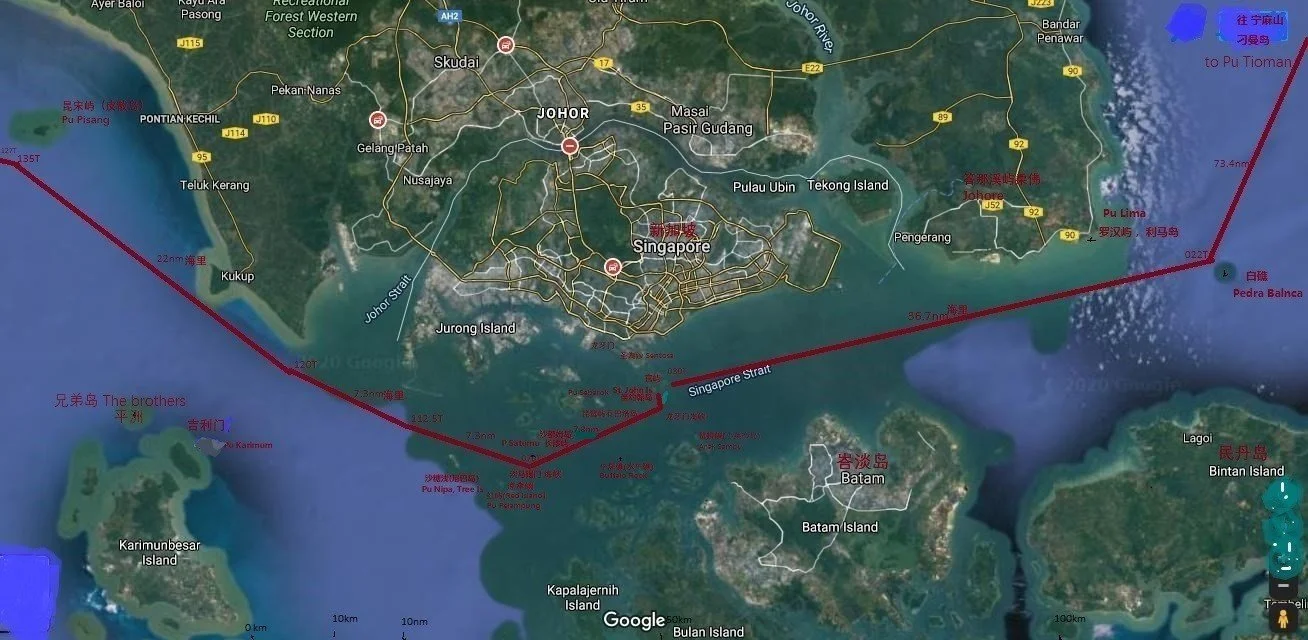
Fig. 16. Based on Fig 1 Record of sailing directions of Shun Feng Xiang Song顺风相送” Malacca Return to Guangdong Directions” and Satellite[KL1] map showing sailing directions and distances with current geographical names
(8) Historical Names and Western Maps
- Singapore was historically called *Temasek* by locals and *Pulau Panjang* (Long Island) by Malays.
Nearby Banc aux Arbresas as Pulau Nipa/Tree Island沙糖礁(尼巴岛)is a very important navigational mark, appear frequently during 16-18 centuries western Singapore Strait chart. )0.3 nautical miles north to Long Island (Pulau Satumu) is Isle la Violle(Pulau Biola or Violin Island with Raffles Light house on it,
- A 1755 French map by Jacques-Nicolas Bellin labels Singapore as *Isle Longue* (Long Island) Fig.17.
Call Singapore as Long Island. Locals also call Sentosa in old times as (Belakang Mati)or Long Island.
I. St Jean as current St. John Island.
- The Spanish explorer Juan de Silva governor of Philippine in 1616 travelled from Malila to Malacca discovered this Singapore Strait and named it the Detroit du Gouverneur (Governor Strait )in the 17th century.
The *Temasek Gate* Chinese and Western in ancient texts both refers to the western section of this Tamasek strait.

Figure 17: 1755 part of the map made by a Spanish: Bellin (held in the National Library of Singapore).
IV. Exploration of Zheng He’s Route Through the Singapore Strait Based on Historical Records
(1) The *Longyamen* (Dragon’s Teeth Gate) mentioned three times in *Daoyi Zhilue岛夷志略* (Summary Account of the Barbarians of the Isles), *Hailu海录* (Maritime Records), and *Xingcha Shenglan星槎胜览* (The Overall Survey of the Star Raft) refers to either the Labrador Park entrance to Keppel Harbour or the passage between the twin stone pillars in the waters off Tanjong Berlayar. In the other eight recorded routes, *Longyamen *(Strait) does not refer to the western entrance of Keppel Harbour. The author believes that the main strait south of St. John’s Island (Pulau Sakijang Bendera) is *Longyamen* (the strait). Wang Dayuan 汪大渊and Fei Xin费信 both mention *Temasek Fan淡马锡番*(Tamasek state), referring to the main island of Singapore as a foreign state. However, in four other routes, *Temasek Men淡马锡门*(Tamasek Gate) refers to the main Singapore Strait, passing 1.5 nautical miles south of Pulau Satumu (Raffles Lighthouse).
(2) The depths recorded in *Dongxi Yangkao东西洋考* (Studies on the Eastern and Western Oceans) for *Longyamen* (Strait) (Figure 15)—30 meters in the north, 45 meters in the middle, and 12–13.5 meters in the south—closely match modern nautical charts of the main Singapore Strait south of St. John’s Island, differing by only 2–3 meters. This contrasts sharply with the 18-meter depth at the twin stone pillars of *Longyamen* (Keppel Harbour entrance), confirming that the waters south of St. John’s Island are indeed *Longyamen* (Strait) 龙牙门(海峡)and not elsewhere.
(3) The routes in *Shunfeng Xiangsong顺风相送* (Fair Winds for Escort) under "Siam to Patani, Pahang, and Malacca," "Guangdong to Malacca Route," "Malacca to Guangdong Return Route," *Dongxi Yangkao东西洋考*, and *Zheng He’s Navigation Map* all clearly state that sailing from Pedra Branca (White Reef) to *Longyamen* (Strait) takes 5 Gengs* (5 × 2.4 = 12 hours).
Three routes—"Siam to Patani, Pahang, and Malacca," "Guangdong to Malacca Route," and *Dongxi Yangkao*—record that sailing from *Longyamen* (Strait) to Karimun Island (Pulau Karimun) takes 3 *geng* (3 × 2.4 = 7.2 hours).
Adopting the consistent 3 Gengs (7.2 hours) from these three routes (instead of the 5 Gengs in Zheng He’s map) better matches the actual distance of 22.1 nautical miles (40.9 km) from *Longyamen* (Strait) to Karimun Island.
The total sailing time for the entire Singapore Strait is 5 + 3 = 8 Gengs (12 + 7.2 = 19.2 hours). Modern nautical charts measure the total distance as 58.8 nautical miles (109 km). Thus, the average sailing speed was 58.8 nautical miles / 19.2 hours = 3.06 knots (5.67 km/h)
Zhang Jiangqi张江齐 [1]calculated Zheng He’s fleet’s average speed as 6.65 km/h (3.59 knots) based on 15 different routes. Given the generally low wind speeds in the Singapore Strait, a calculated speed of 3.06 knots is reliable and acceptable.
At 3.06 knots:
- Pedra Branca to *Longyamen* (Strait, south of St. John’s Island): 5 Gengs (12 hrs.) = 36.7 nautical miles (68.0 km).
- *Longyamen* (Strait) to Karimun Island: 3 Gengs (7.2 hrs.) = 22.1 nautical miles (40.9 km).
Comparing these three routes with modern charts, the path clearly passes through:
- Pedra Branca → Pulau Pima → *Longyamen* (Strait, south of St. John’s Island) → north of Buffalo Rock → south of *Temasek Men* (Pulau Satumu, Coney Island, Raffles Lighthouse) →Pulau Pelampung (Red Island) Sandbank→ north of Pulau Nipa (Tree Island), → Karimun Island.
[1]. Zhang Jiangqi张江齐:Zhenghe Ocean Navigation Astronomical Navigation Technique 《郑和航海天文导航技术》,Liao JianYu 廖建裕 main Editor 2012年,No.103 page
This confirms that *Zheng He’s Navigation Map* depicts a direct route through the Singapore Strait from the South China Sea to the Malacca Strait (or vice versa) without deviation (Figure 16).
(4) The "Malacca to Guangdong Return Route" in *Shunfeng Xiangsong顺风相送* differs slightly from the other three routes. Besides the eastbound route, it specifies a 2 Gengs (4.8hrs) journey from Karimun Island to Pulau Satumu (Raffles Lighthouse), then a 90° course to *Guan Yu* (Official Island) without specifying the duration. From *Guan Yu*, it takes 5 Gengs (12 hrs) to pass north of Pedra Branca. Since the three routes record the entire strait crossing as 8 Gengs (19.2 hours), the distance from Pulau Satumu to *Guan Yu*(St. John Island) must be 1 Geng (2.4 hours × 3.06 knots = 7.3 nautical miles).
This 7.3-nautical-mile distance is crucial, as it confirms that sailing east from Pulau Satumu (Raffles Lighthouse) for 7.3 nautical miles leads to *Guan Yu官屿* (St. John’s Island), located at the 2-nautical-mile-wide *Longyamen* (Strait) (Figure 18).
Any claim that the fleet deviated into Keppel Harbour’s shallow waters via the twin stone pillars would alter the sailing direction, extend the crossing time beyond 8 Gengs, and pose significant dangers.

Figure 18: Malacca to Guangdong Return Route: Pulau Satumu to Guan Yu (depths in fathoms).
(5) The Importance of *Guan Yu* (Official Island官屿) in Singapore
A 1604 hydrographic map of Singapore by Portuguese astronomer-mathematician Manuel Godinho de Eredia labels two southern islands collectively as *Pulo Siquijan* (Malay for "Deer-Barking Island"). One of these is St. John’s Island (Figure 19). The day before Raffles landed in Singapore in 1819, he met Temenggong Abdul Rahman on St. John’s Island, later establishing a signal station and port facilities there. For centuries, the island was valued by rulers and settled by indigenous and Chinese migrants due to its strategic location, deep anchorage, and proximity to Keppel Harbour and the Singapore River and convenient for trading.
The island measures 1,390 meters long and 426 meters wide, with flat terrain suitable for large-scale defense, warehouses, or housing. During the Yongle era, Singapore likely fell under Malacca’s control, making St. John’s Island a Ming-era overseas trade base or transit hub (*Guan Yu官屿*). This reveals a special 600-year historical connection between Singapore and the Yongle court.
Apart from Singapore’s *Guan Yu*, *Zheng He’s Navigation Map* mentions two others, though Ming records lack detailed descriptions. Only Gong Zhen’s account of Malacca’s *Guan Chang官厂* (Official Base) offers clues.

Figure 19: Eredia’s 1604 map showing Pulo Siquijan as St. John’s Island, the location of Singapore’s Guan Yu官屿(Official Island)
The author also discovered 256 ceramic shards (total 3.96 kg) of commoner’s pottery from the late Ming, Qing, and Republican periods at two flat sites on St. John’s Island. These include:
*Late Ming*: Fujian (Jinjiang Cizao kiln晋江磁灶窑) white-glazed pottery jar, Jinjiang brown, black, iron oxide jarlets. Longquan celadon, Dehua blue-and-white, and Zhangzhou blue and white ware.
- *Qing*: Fine blue-and-white, European underglaze plates, British-marked porcelain, Shiwan 石湾green-glazed pottery, Yixing jars.
- *Republican*: Blue-and-white, printed porcelain, Chaozhou 潮州famillie rose and cinnabar tea pot.

Figure 20: Representative ceramic shards found on St. John’s Island by the author.
The ceramic fragments discovered by the author were found only at two surface sites, surrounded by extensive flat areas now covered by modern constructions. Among the fragments are folk kiln ceramics from late Ming Dynasty Quanzhou and Jinjiang Cizao kilns in Fujian, including Yingqing 影青glaze ware, Longquan celadon, and blue-and-white porcelain. The two largest restorable fragments, likely from the base of a tall Cizao kiln 磁灶窑jar, feature a corner-edge-body section measuring 15×11×3.5 cm. Based on the curvature of the rim, the estimated base diameter is 20 cm. Typically, such jars were glazed externally without reaching the bottom edge. These fragments display white clay bodies with a translucent fine-crackled glaze on the interior and base (Figure 21).
The largest shards belong to a Cizao kiln jar (Figure 21), similar to a rare Ming-era jar (Figure 22) collected by the Ex-president of Singapore Zheng He Society Mr Dr. Tan Ta Sen. Legend claims Zheng He used such jars as ballast and storage for water and provision, locals call them Zhenghe Jars or call "Martaban jars" in Southeast Asia but rarely seen in China.

Figure 21: Cizao kiln 磁灶窑shards from St. John’s Island.

Figure 22: Ming Yongle-era Cizao kiln brown-glazed jar. Collection by Dr. Tan Ta Sen
The late Ming and early Qing Fujian wares suggest early Chinese settlement。
In 1991, an archaeological team from the History Department of the National University of Singapore conducted a survey and collected a small Yongle blue-and-white porcelain teacup from the coast of Pulau Semakau (see the author's article ["Zheng He Fleet's Blue-and-White Teacup"] link:(https://www.limkw.com/zhenghe/guanyu/singapore/chinese/3wb2i7en7lu4jt75nod5urga6mfi5t)
This small blue-and-white teacup found on Pulau Semakau (Fig. 22B) is identical to (1) the family heirloom blue-and-white teacup preserved by descendants of the shipwrecked Zheng He crew members in Kenya, and (2) the Yongle blue-and-white teacups recovered from shipwrecks near Malacca. All these were teacups used by the Zheng He fleet. Pulau Semakau is located just 10 km west of St. John's Island (Guan Yu) (Fig. 22C). It is highly probable that the inhabitants of St. John's Island (Guan Yu) later transferred this Ming Dynasty teacup to Pulau Semakau
All these support the author’s identification of St. John’s Island as *Guan Yu官屿 (St. John’s Island) *. Further archaeological work could confirm Zheng He’s activities in Singapore, filling gaps between the fall of Temasek and the Portuguese destruction of Singapore’s settlement in 1613.

Fig 22B, In 1991, A Yongle (incorrectly labeled as 19-20 century) blue-and-white passion fruit porcelain teacup was discovered on the coast of Pulau Semakau. Collection by Singapore National University Museum.

Fig 22C, Discovery of Yongle Blue & White tea cup on Pulau Semakau is located 10km west of St. John's Island 官屿 (Guan Yu)
(6) Debating Mr. Lim Woling’s Views
Lim Woling argued that * Dragon’s Teeth Gate龙牙门 (Long yamen Strait) * was at the northern mouth of the Riau Strait (between Batam and Bintan), while *Temasek* was at its southern mouth. He claimed Zheng He’s fleet avoided the main Singapore Strait, instead detouring south after Karimun via Durian Strait, from Pulau Durian Bersa proceed east pass Pulau Gelang which is south of Batam Island through Selat Tempo strait, and sail north through the Riau Strait, Exit north exit of Riau Strait then proceed to White Reef (Pedra Blanca) (Figure 23). In other words Zheng He avoided the Singapore main strait, steaming on a longer and more dangerous Durian and Selat Tempo straits.
Figure 23 According to Mr. Lim Woling’s book《New Examination on Longyamen龙牙门新考》Zhenghe's routes
The author disputes Zheng He’s fleet passed through Durian and Riau Strait for 5 reasons:
1. Dangerous Routes: Durian and Tempo Straits 灯婆 (Selat Dempo) to Riau strait, Durian Bersa 大榴莲岛and 加朗岛Pulau Galang have reefs and shallow depths (≤6 m), Do not match 《郑和航海图》unsuitable for Zheng He’s deep-draft ships (>6 m). Navigators would not make decision disregard the grounding danger to pick these routes.
2. Navigation Impossibility: The route requires 12 course changes (vs. only 2–3 in Ming records), including due north/south legs, contradicting *Yingya Shenglan*’s westward headings at *Longyamen*.
3. Inefficiency: The detour spans 135 nautical miles (251 km) vs. the main strait’s 58.8 nm (109 km).
4. Time Discrepancy: At 3.06 knots, the detour through Durian and Selat Tempo straits would take 44.2 hours (18.4 Gengs), far exceeding the recorded 19.2 hours (8 Gengs) through the Singapore Main Strait.
5. Toponym Mismatch: Zheng He’s route mentions Longyamen, Buffalo Rock, Temasek Men, Sugar Shallows沙糖浅(Now Pulau Nipa /Tree Island), and Sandbank—all in the main Singapore Strait, unrelated to Durian/Tempo/Riau Straits.
Thus, Author proved Zheng He’s fleet unequivocally traversed the main Singapore Strait between the South China Sea and Malacca Strait.
1. In 1957 according from a Rudder stock excavated at Nanjing Treasure Ship Shipyard南京宝船厂, Can predict height of the rudder blade is 6m, it means the maximum draft of the Treasure Ship宝船 exceed 6m.
(II) The Route East of Lingga Island 凌牙岛
Ancient texts record the following about voyages from the South China Sea to Lingga Island, Jambi, and Palembang:
1. 《Daode Nanhai Zhi大德南海志》 (Great Virtue Annals of the Southern Sea) lists places under Srivijaya’s rule:
- Longyashan龙牙山, Longyamen龙牙门, Bianshu便塾, Lanbang棚加, Bulidong不理东, Jianbi监篦, Yalu哑鲁, Tingting亭停, Bula不剌, Wusixin无思忻, Shenmotuoluo深没陀啰, Nanwuli南无里, Busima不斯麻, Xilan细兰, Meilipadu没里琶都, Bincuo宾撮.
This shows that Longyashan龙牙山(Lingga Mountain )and Longyamen龙牙门 (Dragon Teeth Gate at Singapore Island) were two distinct but nearby places under Srivijaya.
2. "Dongxi Yang Kao东西洋考" (Study of the Eastern and Western Oceans) records:
- Merchant ships departing from Yuegang月港(at Fujian Zhangzhou Jiu Long Jiang river mouth )sailed south past Nanao Island南澳岛, Jiaozhiyang交趾洋,
Xinzhou Port新州港, Chijiu Mountain赤九山, Kunlun Mountain毗仑山( Poulo Condore), and Dongxi Zhu 东西竺 (Pulau Aur), passing Longya Dashan 龙雅大山 (Lingga Island) and Pengjiashan彭加山(Bangka Island) before reaching Jambi and Palembang (Srivijaya).
During the Ming dynasty, this route went from Dongxi Zhu (Pulau Aur) past Longya Dashan before reaching Pengjiashan (Bangka Island) and onward to Jambi and Palembang.
3. "Zhufan Zhi诸蕃志" (Records of Foreign Nations), Volume 1,
"Srivijaya三佛齐" - Located due south of Quanzhou泉州, with favourable winds in winter, it took over a month to reach Lingyamen凌牙门 (Lingga Island), where a third of the goods were traded before entering the country.
In 1989, a Northern Song-era shipwreck of Indonesian origin was discovered near Crocodile Island, 20 nautical miles northwest of Lingga Island (Figure 24). It yielded large quantities of ceramics from Guangdong’s Bijiashan 笔架山and Qishi kilns奇石窑, along with iron materials. One broken Qishi kiln 奇石窑jar bore the inscription "Zhenghe Sixth Year政和六年" (1116 AD, Figure 25). The related navigational course is recorded in *Shunfeng Xiangsong顺风相送*: "From Malacca to Palembang, take a single *Bing丙* (150°) and *bing-si丙巳* course for ten *Gengs* (24 hrs.) to reach Crocodile Island."
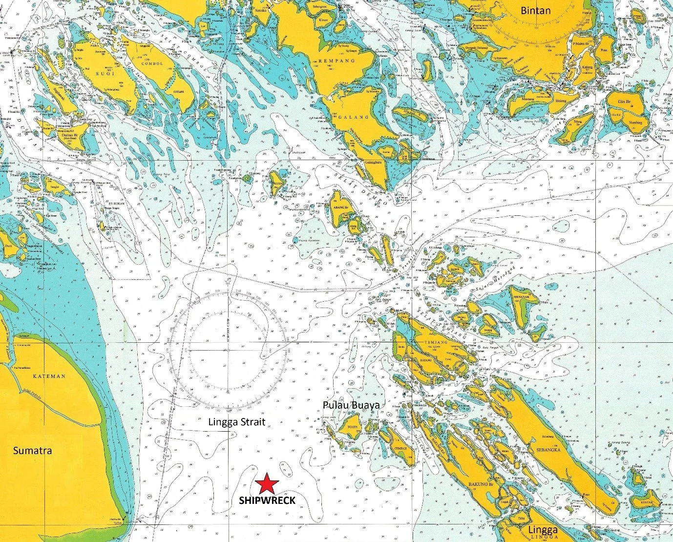
Figure 24: Location of the Northern Song shipwreck near Lingga and Crocodile Islands, Indonesia.
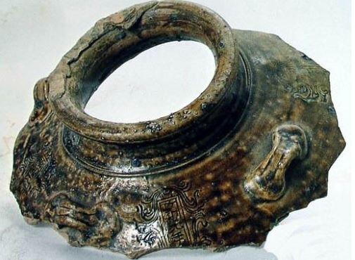

Figure 25: Northern Song shipwreck artifacts from Crocodile Island waters—a Qishi kiln奇石窑 four lugs stamped jar.
During the Song dynasty, due to the character "Ling凌" in "Lingyamen凌牙门this referred to Lingyamen on Lingga Island. Thus, before reaching Srivijaya, a third of the cargo was unloaded at Lingga Island, not Singapore. Yuan-era blue-and-white porcelain from Jingdezhen was also a common export to Indonesia.
4. "Shunfeng Xiangsong顺风相送Zhupan Mountain苎盘山 (刁曼岛,Pulau Tioman)to Palembang and Shunta Routes并顺塔针路(follow the light house and compass routes":
- From Zhupanshan (Pulau Tioman), sail past with a Bing-Wu丙午* (172.5°) course for ten Gengs to Changyu长屿 (here referring to Bintan Island). Then take a Ding-Wu丁午针 (187.5°) course for ten Gengs (24 hrs. or 94.8 nautical miles) to Longyamen Mountain龙牙门山 (Lingga Mountain), use a single Wu午针 (180°) course for three Gengs(7.2 hrs.) to reach Mantouyu馒头屿 (Pulau Saja). Then take a single Ding丁 (195°) course for three Gengs (7.2 hrs.) to Qiyu七屿. Near the second mountain on the Fanpu帆铺 (on the right side of the sail) lies a submerged reef. Use a Kun-Shen坤申 (232.5°) course to reach the main route to Palembang. Finally, take a Chen-Xun辰巽* (127.5°) course for ten Gengs (24 hrs.) to enter the entrance of strait.
5. "Dongxi Yang Kao东西洋考," Volume 9:
- From Changyao Island长腰屿 (here referring to Bintan Island/Pedra Branca), take a Ding-Wu丁午 (187.5°) course for ten Gengs (24 hrs. or 94.8 nautical miles at 3.95 knots) to Longya Dashan龙雅大山, take a single Wu单午针 (180°) course for three Gengs (7.2 hrs or 28.4 nautical miles) to Mantouyu取馒头 (Pulau Suja). From Mantouyu, it is seven Gengs (16.8 hrs. or 66 nautical miles) to Jambi詹卑.
6. "Hai Lu海录" Volume 2":
- Longyaguo kingdom龙牙国 (Liuliguo溜哩国) is located north of Palembang and southwest of Johor, an alone large mountain. Crossing south from Johor by sea takes about a day to reach, covering several hundred li里(0.5km) The island is heavily forested, with trees dozens of arm-spans wide. Chinese merchant ships often replaced masts and rudders here. The people are mostly of the Malayu ethnic group, except for the more civilized Aceh and Susu, while others are fierce and prone to piracy. Products include black bird’s nests, Agarwood速香(non sinkable type), Laka wood降香and 鸡骨香, betel nuts, coconuts, and seaweed.
The author speculates this refers to Lingga Island凌牙岛 in the Lingga Archipelago, not the Riau Islands south of Johor, as the largest island in the Riau group, Bintan, is only 13 nautical miles or 1.4 Gengs (3.36 hours) away—not "over a day’s journey."
Routes 4 and 5, from different ancient texts, share the same departure and midway courses. The only difference is that Route 4 ends at the more distant Palembang, while Route 5 terminates at the closer Jambi. Thus, the author adopts Route 5 to plot the course to Jambi in Figure 26. The chart clearly shows the actual route from Bintan Island → Longya Dashan (Lingga Island) → Mantouyu (Pulau Suja) → Jambi Port.

Figure 26: Actual Ming-era route from Bintan Island via Lingga Island凌牙岛 (Longya Mountain龙雅山) to Jambi Port, based on navigational records.
Based on these historical accounts of Lingga Island, different routes—varying in heading, speed, and distance—all passed through Lingga Island. Lingga Island and Longyamen were two distinct but similarly named places. However, *Zheng He’s Nautical Charts* mistakenly labeled Lingga Island on the map east of Pedra Branca as Longyamen. Whether this was Mao Yuanyi’s editorial error, a carving mistake on print wooden block, author’s view more likely is due to big scale map with very non accurate distance scale and directional position used, Lingga Island actually is 94.8 nautical miles south of Pedra Branca or Bintan We must distinguish between:
1. * Longyamen龙牙门* and *Longyamen Strait龙牙门峡*: the two stone pillars in Keppel Harbour and the main Singapore Strait.
2. *Lingga Archipelago’s major island*: Lingga Island, Longyamen Mountain, Longya Mountain, Longya Dashan(large mountain)龙雅大山, Lingyaguo凌牙国 (Lingya Kingdom), Longyaguo龙牙国 (Liuliguo溜哩国/Dragon Teeth Kingdom).
(III) The Northeast Coast Route Along Sumatra
Ancient texts record the following about voyages from the Malacca Strait to Jambi and Palembang:
1. "Siyi Guangji四夷广记" (Expanded Records of Foreign Lands), "Malacca to Palembang and Return Routes":
- From Ganbamen甘巴门 (Kampar strait, west of Pulau Kundur), take a single Gan干 on (315°) course for four Gengs (9.6 hrs.) to Renyi Reef仁义礁 (Batu Buruk). Near Kamparport approach甘巴门港口, beware of Niushijiao牛屎(毗)礁 (Pulau Belembang Rock), which is submerged at high tide. Sail closer to the northern in the middle for safety. Take a single Ren壬(345°likely error, should be Bing 丙(165°) and Ren-Gui壬 -癸(345°-015° likely error )(should be Bing-Ding丙-丁165°-195°)* courses pass the eastern side of Guiyu 鬼屿(Ghost Island, Pulau Langsang).
2. "Xiyang Chaogong Lu西洋朝贡录" (Records of Tributes from the Western Oceans), Volume 1, "Malacca Kingdom":
- From Palembang, sail ten Gengs (24 hrs.) past Guanyu官屿 (Pulau Berhala) to the left, then five Gengs to Changyao Island 长腰之屿 (a small island northwest of Lingga Islands), sighting the island of Srivijaya 三佛屿(Singkep Island) and Bieyu鳖鱼 (turtle island). Another five Gengs (12 hrs) leads to Ganbamen’s 甘巴门 (Kamparstrait) swift currents, with Renyi Reef仁义礁 (Batu Buruk) to the right, Niuweijiao牛尾(毗)之礁 (Pulau Belembang) to the left, and Guiyu鬼屿 (Ghost Island, Pulau Langsang) ahead. Five more Gengs(12 hrs.) brings one to Pisong Island披宋之屿 (Pulau Pisang), another five Gengs(12 hrs.) to Shejian Mountain射箭之山(Batu Pahat, Gunung Banang), and five more five Gengs(12 hrs.)to the Five Islands (Pulau Lima), following the coast to reach the kingdom (Malacca).
3. *Fair Winds for Escort顺风相送[KL1] * – "From Malacca to Palembang":
Set sail on a Chen-Xun辰巽 (127.5°)* course for five Gengs (10 hrs. or 47.4 nautical miles) to Shejian Mountain射箭之山(Batu Pahat, Gunung Banang), sounding 20 Tuos(30m) . Chen-Xun辰-巽 (127.5°) for three Gengs (28.4 nautical miles) to Pisong island毗宋屿(Pulau Pisang), where shallow waters lie to the west, with depth 4-5 Tuos(6-7.5m)on Xun-Si巽巳 (142.5°) and Dan-Si 单巳 (150°) for five Gengs (47.4 nautical miles) to Pulau Kerimun—avoid sailing at night. Bing-Si 丙-巳(157.5°) and Dan-Si 单-巳(150°) for four Gengs (37.9 nautical miles) pass southeast of Ghost Islet (Pulau Rangsang) through the Gelang Strait格兰峡; beware of the Dung Reef牛屎(毗)礁 to the southwest, which is submerged at high tide. Opposite lies the Gamba Strait甘巴港口, where the Renyi Reef 仁义礁 is located. Dan-Xun单巽 (135°) for four Gengs (9.6 hrs. or 37.9 nautical miles) crosses the Gamba Strait甘巴港. Dan-Si单巳 (150°) for four Gengs (9.6 hrs or 37.9 nautical miles) passes west of Buddhist Temple Islet 佛寺屿Dan-Si 单巳(150°) for four Gengs (9.6 hrs. or 37.9 nautical miles) reaches Single Islet单屿 Dan-Si (150°) and Bing-Si丙巳 (157.5°) for five Gengs(12 hrs. or 47.4 nautical miles) follow the coast at 6-7 Tuos(9-10.5m), then another five Gengs (12 hrs. 47.4 nautical miles) to the Palembang estuary旧港口, where a central low land marks the correct route—navigate carefully.
Plotting this well documented compass routes on modern nautical charts (Fig. 27) and satellite map (Fig. 28), assuming a speed of 3.95 knots (nautical miles/hour), where 4 Gengs = 3.95 × 2.4 × 4 = 37.9 nautical miles, allows precise mapping of passing route courses with all landmarks and submerged reefs mentioned.
4. Fair Winds for Escort顺风相送– "Return from Palembang to Malacca":
Set sail on a 壬癸 (likely error Ren-Hai壬亥 (337.5°) course for three Gengs to the tail of Bangka island here submerged reefs and shallow sands are passable. Sail along Kunson毗峷(low sand bank), sounding 6-7 Tuos(9-10.5m). Dan-Gui单癸 (15°) for ten Gengs (24 hrs.) to ingle Islet单屿. Dan-Ren 单壬 (345°) for four Gengs to Buddhist Temple Islet佛堂屿. Dan-Hai单亥 (330°) for four Gengs (9.6 hrs) to Crocodile Islet 鳄鱼屿Ren-Hai壬亥 (337.5°) and Dan-Ren单壬 (345°) for ten Gengs (24 hrs.) to the Gamba Strait甘巴门. Dan-Qian单干 (315°) for four Gengs (9.6 hrs) to the Renyi 仁义礁 and reef. Approach the **Gamba Strait甘巴门港口 cautiously to avoid the submerged Ox Dung Reef牛屎礁; staying closer to the northern middle line is advisable. an-Ren单壬 (345°) and Gui 癸(015°) pass east of Ghost Islet through the Gelang Strait. Dan-Ren 单壬 (345°) for four Gengs to Pulau Kerimun. Dan-Hai 单亥 (330°) for four gengs past Pulau Pisang, here shallow waters 4-5 Tuos(6-7.5m) lie to the west. Dan-Hai单亥 (330°) and Qian-Hai 干亥 (322.5°) lead to the Great and Small Shooting Arrow Hills 射箭山(Batu Pahat, Gunung Banang). Dan-Qian单干 (315°) for five Gengs to the Five Islets五屿(Pulau Lima), inside which lies Malacca.
The return route mirrors the outbound journey exactly, only with a 180° reverse courses.

Fig. 27 Fair Winds for Escort顺风相送 route from Malacca to Palembang, passing Pulau Karimun, Gelang Strait, and Kampar Strait

Fig. 28 Satellite image of Pulau Kerimun, Gelang Strait, and Kampar Strait.
These four compass courses records describe the same route through the Gelang Strait and Kampar Strait, confirming it as Zheng He’s third major route in this region, with no mention of alternative passages.
Modern ships traveling from Pulau Kerimun to Jambi詹卑 now take the deeper Durian Strait which has more shoals and reefs than Gelang and Gamba. However, with radar, navigational aids, and lighthouses, safe passage is possible—unfeasible for ancient sailing ships. This remains the shortest route from the Malacca Strait to Jambi, by passing Singapore’s main channel.
This study employs navigational science and historical records to clarify debates regarding Zheng He’s Nautical Chart郑和航海图 in Singaporean waters, proposing:
1. Temasek was on Singapore’s main island, with its palace at ort Canning Hill
2. The Dragon’s Teeth Gate 龙牙门rock pillars stood at the western entrance of Keppel Harbour near Labrador Park.
3. The Dragon’s Teeth Strait 龙牙门(海峡)was just south of St. John island in the main Singapore strait.
4. Lingga Island凌牙岛 refers to Indonesia’s biggest island of the Lingga Archipelago.
5. Temasek Strait淡马锡门(海峡) lies in Singapore’s main channel, south of Changyao Islet长腰屿 (Pulau Satumu, Raffles light house).
6. Zheng He’s 官屿 in Singapore is on St. John Island.
Zheng He’s three primary routes in this region confirm he never traversed the Durian ,Selat Tempo, or Riau Straits, invalidating the 《New Study of Dragon’s Teeth Gate龙牙门新考》 theory.
Unlike prior studies, this work combines navigational science, historical texts, and new evidence to resolve past ambiguities, particularly my discovery of Singapore Guanyu(Official Island 官屿)definitive location and its historical significance. I welcome further scholarly and archaeological exploration. Any omissions or errors are mine alone.
By Captain Lim Keow Wah
9 Jun 2025
Contact: Email – limkeowwah@gmail.com | WeChat – lkwah1953
© **Captain Lim Keow Wah**. Unauthorized reproduction prohibited.